Be Excellent To Each Other

And, you know, party on. Dude.

All times are UTC [ DST ]


Reply to topic  [ 23 posts ] 
Author Message
 Post subject: Hurricane Watch
PostPosted: Thu Aug 25, 2011 13:59 
User avatar
Excellent Member

Joined: 30th Mar, 2008
Posts: 8057
Location: Cardiff
Hurricane Watch:

So, the first big storm of the season is currently working its way over the Bahamas and headed North West. This is Hurricane Irene, a girl big in girth and a tad strong. She's currently a category 3 with winds of 111-130mph, but once she's wobbled her way over the islands she's set to briefly punch up to a category four, adding another twenty mph onto that spread. Where next and at what strenght are the questions currently bedevilling the fine minds of NOAHH.

Well currently we're looking at Hurricane force winds in the Bahamas today. Storm surge is going to be between seven and eleven feet above tide level, and there's going to be between 6 and 12 inches of rain over the following couple of days. According to storm surge maps the George Town area (population 1,000) on Exuma Island can expect an 18 to 20ft surge. The eye of the hurricane is passing a little west however, and the main punch of a Northern moving hurricane sits in its eastern arm, so I have a hunch the surge won't be quite that bad. However, it is a small island, so things will be dicey. If people heed advice and battern down they should all be fine, though there will be heavy property damage.

Once Irene has passed the Bahamas it will briefly intensify, however the storm is due an eyewall replacement cycle. This happens when the central core, the eyewall, of a hurricane tightens and a new wider wall forms around it, robbing it of strength by stealing the air inflow. Eventually the inner core disipates to be replaced by the new one, which in turn tightens. In practice this means that the hurricane usually drops a category, even two, during the process. However, once complete it can easily reintensify given a warm enough mass of water.

The Western Atlantic is currently a few degrees above seasonal average, and it is this that is fuelling this storm. Currently predictive tracks place the hurricane as making landfall somewhere around the outer banks of North Carolina on Saturday morning (their time) as a category 2 and then brushing the coast, briefly leaving land again and hitting the Cape Cod - New York to Long Island area as anything between a category one and two.

So, not an apocalyptic hurricane, but one that could cause a fair bit of property damage on Long Island. The last time a Hurricane hit New York was a category 3 in 1938, with most of the 800 casualties being on Long Island. It cost ten billion dollars, but a similar hit would triple that figure today. But happily if she stays category 1-2, with today's warnings, loss of life should be minimal. Currently we are very much in the 'cone of uncertainty'. Stay posted to find out where she rolls.

http://www.wunderground.com/hurricane/IslandsSurge.asp

#commenttop">http://www.wunderground.com/blog/JeffMa ... commenttop

_________________
"Peter you've lost the NEWS!"

Bored? Why not look at some pretty pictures on my photography blog? Here: http://petetakespictures.com

Come & See My Flickery Pics Here: http://www.flickr.com/photos/nervouspete/


Top
 Profile  
 
 Post subject: Re: Hurricane Watch
PostPosted: Thu Aug 25, 2011 18:34 
Filthy Junkie Bitch

Joined: 17th Dec, 2008
Posts: 8293
If this does hit new jersey as predicted it could get messy financially. Curiosity may confirm, but insurers don't do big risk analysis on eastern seaboard storms that hit land far north of Florida. As the first storm of the season it could therefore be messy as there is likely to be at least one gulf of Mexico storm this year which would account for the "normal, expected" loss.


Top
 Profile  
 
 Post subject: Re: Hurricane Watch
PostPosted: Thu Aug 25, 2011 19:24 
User avatar
Excellent Member

Joined: 30th Mar, 2008
Posts: 8057
Location: Cardiff
Image

Nassau, at daybreak, under a glancing blow. Remarkably little damage reported, but looks cool.


It could get messy indeed, ApplePie, how messy detailed near the bottom of this michty post. I don't think it will, but the chance is there for big trouble in New York and New Jersey.

So, new stats have been released, models and maps updated, and sugary beverages been consumed in the journalist plagued centre at NOAA. Dr. Jeff Masters breaks all this down into simple words for laymen like myself to understand. So, what's going down? Here I am to obscenely plagarise Dr. Jeff Master's Wunderblog, only without the confusing charts and number crunching.

First an update on the Bahamas. The category 3 hurricane with winds of 115mph is still tracking through the region hitting the evocatively named Crooked, Long, Rum and Cat islands. The sparsely populated Lovely Bay settlement on Acklins Island is reported to have been devastated, but there have been no reports of casualties.

Irene will ride right over Eleuthera and Abaco Island, both populated by some thousands of people. Storm surge is once again the main concern, however these two islands have a trick up their sleeve. They both have extensive reefs, and these are incredibly good at breaking up surges and tidal waves. Here's hoping they do the trick. The main population centre of the Bahamas, Nassau City, will get away with a minor glancing blow, as will Grand Bahama. Irene is currently undergoing its eyewall replacement cycle too, and that won't be complete until Friday, so that'll take a little sting out of her.

What then? Well other than the eye-wall replacement cycle there's also some high-altitude wind sheer pumping 15-20 knots against her rotation. This effectively drags the hurricane and weakens it a touch. There is a chance also that this sheer will punch a hole in her and inject some dry air into her core. Hurricanes are fueled by moisture, and dry air is their kryptonite. However models put the chances of that at 10%, so don't bet on it. This drag will however persist over the next three days, acting as a little brake. Experts are divided on how much an impact this will have. Some say it will seriously weaken Irene, others reckon that in the past such big storms have simply powered through such problems. At the very least though, such sheer is welcome. Hurricane Katrina was belted by a very unlikely blast of heavy sheer and unpredicted dry air coming in at the last moment, tilting her to the West away from the direct hit and weakening her from a category five to a category three. This effectively saved fifty thousand lives in New Orleans. So meteorologists are putting a lot more study now into such phenonoma.

What of her strength? Currently ocean temperatues are a very warm 29c and will remain so for three days at least. Although most analysts are saying a category three is the upper level, and sticking by that, a slightly troubling last four runs of the ECMWF global modelling system - described as Dr. Jeff Masters as the best forecasting model - has it bumping up to a category 4 with a plunge of pressure down to 912-920mb as it crosses over Eastern North Carolina.

Image

From't Beeb.

What of the track? Well, the track has been refined a little, moving a touch West. This puts a hit on North Carolina as very likely, the question is now whether the hurricane will curve inland a touch, weakening and dumping much welcome rain on the drought-stricken Eastern states (and on one hell of a stubborn nasty wildfire) or run straight North and cross the outerbanks, reintensify and hit New Jersey and New York. The ECMWF model and GFDL (no, I have no idea what those acronyms mean, they might mean Ectoplasmic-Cunt-Munching-Wiffle-Factor and Gecko-Friendly-Dyson-Libido for all I know) place her as moving inland over Moorhead City. This is currently pegged as the likeliest hit (population 7,000 - once again Americans confusing the word 'city' for 'town') and when she leaves land again to track towards New York and New Jersey, her extended stay over land will sap so much strength that she might no longer be a hurricane when she reaches the city.

However! The GFS (Granny-Fapping-Synthesis) has her curving a little East, grazing the outerbanks and putting her at a category two for New Jersey and a category one for New York. This would mean a category two landfall on Long Island.

Category 2 doesn't sound so bad, and I wasn't particularily worried, but now a couple of additional factors have been raised. Now, part of my complacency is that Hurricane Bob of 1991 hit Rhode Island at a category 2 and did only a piffling 1.5 billion in damage, with few deaths. But it turns out Hurricane Bob was a small sized hurricane despite its wind speeds, and Irene is a lot wider. NOAA now put her at a category 3/4 on storm surge. This is because her wider mass piles up more water, and her slower movement gives her more time to accumulate a big surge.

Now, this sounds worrying, but I'm still a little sceptical. If anyone remembers Hurricane Ike from 2008 I was crying panic over that one too, and that's because although she was a category two she had a huge width and all the scientists were crying up how she was going to have a huge storm surge. A bad storm surge there was, with 112 deaths, but no where near the horror story predicted for the 58,000 who couldn't be arsed evacuating. Scientists frankly are still at a loss as to how their models were so far out on that one.

Still, Masters is worried, and for this additional reason: high tide. If she hits, it will likely coincide with not only the high tide but also full moon. There's a possibility - slim, but there - of a category three storm surge on Long Island, and a category two on New York.

Obviously this is all reliant on sub-topography. In some areas waters will be funnelled, in others repelled. For New Jersey, Delaware, Ocean City and Atlantic City a category 1 surge can, according to models, reach 5-9 feet. With high tide and added pile-up owing to slow speed, a category 2 surge would bring 10-15 feet - but probably only 6-8 feet for the metropolitan areas. Masters gives a 30% chance of deeper than ten feet for the general, lesser populated area.

The model used for storm surges, the wonderfully named SLOSH, is rather sketchy with a plus or minus factor of 20% on heights, and its ability has been called into question since Ike. It has proven right in the past though. Sometimes.

What Irene means for New York:

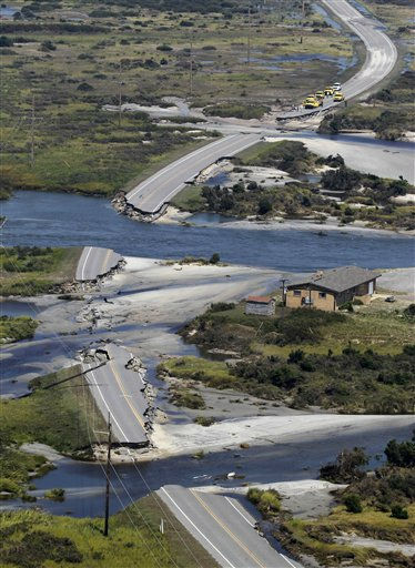
Manhattan is protected by floodwalls of five feet high above mean sea level. During a nor'easter in 1998 heavy winds of a 990mb storm pushed an eight foot surge into battery park, which overtopped the walls and flooded the NYC subway and the Hoboken New Jersey subway. Lower Manhatten experienced 4 feet of flooding. Mass transit was offline for ten days. Aside from that New York has done okay flood wise, with Long Island bearing the brunt of the 1938 hurricane. However, in 1821 the only hurricane ever to make a direct hit on the city, a category two, made a flood of 13 feet in just one hour at Battery Park, reaching up to where the Financial District is now. SLOSH predicts that a mid-strength category 2 storm of 110mph (a little under what the Bahamas are getting right now) would drive a 15-20ft storm surge into Manhattan, Queens, Kings and up the Husdon river - owing entirely to the funnelling effect of the bay. Power plants would be knocked out, infrastructure badly damaged and the New York docks destroyed. This is quite unlikely, probably in the order of 5%. Slightly more likely at 20% is the category 1 hit with an 8-12ft surge.

So, what to do if you live in New York? First off, don't expect Roland Emmerich. As the mighty Morbo cries, "Hurricanes do not work that way!" Do reckon on a chance of an evacuation order, especially likely if you are in Carolina, somewhat more slimmer in New York's coastal regions. The storm will hit on Sunday, so have a plan and be prepared just in case.

What does Pete predict? Currently North Carolina, slight inland track, four hundred million or so in damage, welcome relief for drought areas. This prediction will change in't coming days, though, as more cards are revealed.

Meanwhile, tremendous footage from the ISS here: http://www.nasa.gov/multimedia/videogal ... =108144931

_________________
"Peter you've lost the NEWS!"

Bored? Why not look at some pretty pictures on my photography blog? Here: http://petetakespictures.com

Come & See My Flickery Pics Here: http://www.flickr.com/photos/nervouspete/


Top
 Profile  
 
 Post subject: Re: Hurricane Watch
PostPosted: Fri Aug 26, 2011 2:53 
User avatar
Excellent Member

Joined: 26th May, 2008
Posts: 298
As you can imagine, I'm not looking forward to the weekend…(had my first tornado scare in Raleigh earlier this year, too!). Hopefully, we're far enough inland that we'll get the rain but little else!


Top
 Profile  
 
 Post subject: Re: Hurricane Watch
PostPosted: Fri Aug 26, 2011 9:46 
User avatar
Excellent Member

Joined: 30th Mar, 2008
Posts: 8057
Location: Cardiff
Where you at Peter?

_________________
"Peter you've lost the NEWS!"

Bored? Why not look at some pretty pictures on my photography blog? Here: http://petetakespictures.com

Come & See My Flickery Pics Here: http://www.flickr.com/photos/nervouspete/


Top
 Profile  
 
 Post subject: Re: Hurricane Watch
PostPosted: Fri Aug 26, 2011 10:08 
User avatar
Excellent Member

Joined: 30th Mar, 2008
Posts: 8057
Location: Cardiff
Strange things afoot with Irene, she's just completed her eye-wall replacement cycle, but as she's been doing so she's been subject to dry air from the West coming in over Florida, and hampering her ability to form a coherent, classic hurricane. What she's become is one huge, raggedy, flailing thing that keeps looking as if she's going to rip herself apart. However, to check this there is nourishing moist air coming from the East and 24 hours of warm water ahead of her. This is the crucial period which will reveal whether or not Irene is going to hit as a category two or three on North Carolina, and whether she will be a category one or a very strong tropical storm with an unusually large mass for the New Jersey and New York area. I'd say the chances of a category two for New York are pretty low now, in the area of 5%.

It also looks as if she wasn't happy with her new eyewall and is trying to make another. If she can quickly form up another in the next twelve hours and take advantage of warm waters, she could stick around at a category 3, otherwise she will significantly weaken. However, this is a storm where strong hurricane force winds are being felt 75 miles from centre, so she is very big and cannot be broken up at all easily. Whatever happens, North Carolina will be in a tricky situation in 24 hours.

Keep watching.

_________________
"Peter you've lost the NEWS!"

Bored? Why not look at some pretty pictures on my photography blog? Here: http://petetakespictures.com

Come & See My Flickery Pics Here: http://www.flickr.com/photos/nervouspete/


Top
 Profile  
 
 Post subject: Re: Hurricane Watch
PostPosted: Fri Aug 26, 2011 10:15 
User avatar

Joined: 12th Apr, 2008
Posts: 17924
Location: Oxford
Thanks for the updates.
I think Peter St John said in the Yay thread that he was going to, er, North Carolina, so I hope he keeps safe.


Top
 Profile  
 
 Post subject: Re: Hurricane Watch
PostPosted: Fri Aug 26, 2011 11:23 
These updates are very informative and interesting. Thanks Pete!


Top
  
 
 Post subject: Re: Hurricane Watch
PostPosted: Fri Aug 26, 2011 12:44 
User avatar
Excellent Member

Joined: 30th Mar, 2008
Posts: 8057
Location: Cardiff
Peter St. John, if by any chance you can get at internet access and if, for example, you don't mind interupting a well-earned holiday purely to indulge a nerdish curiousity, could you keep us posted on conditions there? That is if you've made it safely and all.

If you're on the coast, obviously get out. In fact, they'd probably be forcing you to. If you're further in land, anywhere in the state, be aware of the possibility of inland flooding. Irene is going to dump a hell of a lot of water on the state, and contrary to my earlier drought-neediness thought she's already received a lot lately in the last few days, so the ground is sodden and saturated. More than fifty miles inland you should be fine as far as winds go, it'll merely be a question of flying branches, but yes, flash flooding is a danger.

It's very hard to call what effect Irene will have. There's more sheer forecasted and it appears as if her low pressure has peaked, with it rising back up a touch to 938mb. We also haven't yet seen force winds consistent with that low pressure. Can Irene get it together? So it's looking increasingly like a category two for North Carolina, and increasingly unlikely for anything more than a category one for New Jersey.

These are very strange, baffling hurricanes - and they've only been a feature of the last few years. Since 2008 there has been a parade of very large, but relatively low category storms that keep threatening to shape up but never quite keep it together. The aforementioned Ike was one, but also Gustav, Alex and Earl.

Current storm surge models vary all up and down the coast for North Carolina, some areas have only a few feet whilst towns like Norfolk have patches in the 8-15ft range. But no one is yet sure exactly what's going to happen with this one.

_________________
"Peter you've lost the NEWS!"

Bored? Why not look at some pretty pictures on my photography blog? Here: http://petetakespictures.com

Come & See My Flickery Pics Here: http://www.flickr.com/photos/nervouspete/


Top
 Profile  
 
 Post subject: Re: Hurricane Watch
PostPosted: Fri Aug 26, 2011 15:58 
User avatar
Excellent Member

Joined: 26th May, 2008
Posts: 298
Thanks, Kern ;). I'm in Durham, North Carolina, which I think is far enough inland that we should be spared from the worst. One of our friends has gone to rescue his parents from the Outer Banks, so hopefully they'll be back here later today! I'll let you know how things go - current track seems to put landfall tonight, I think…


Top
 Profile  
 
 Post subject: Re: Hurricane Watch
PostPosted: Fri Aug 26, 2011 16:41 
User avatar
Meh

Joined: 13th Apr, 2008
Posts: 1643
Great stuff Pete. Very interesting read.

_________________
Turn your wounds into wisdom


Top
 Profile  
 
 Post subject: Re: Hurricane Watch
PostPosted: Fri Aug 26, 2011 17:24 
User avatar
Excellent Member

Joined: 30th Mar, 2008
Posts: 8057
Location: Cardiff
Durham, you say?

From what I understand Durham will escape the hurricane winds, though those do extend currently to just over 90 miles from the eye - a very wide reach, though of a lower intensity than near the eye. Your current place is 320 miles from landfall and tropical storm force winds (around 45mph) only reach 290mph from the eye, so you'll have some blustery weather but will be well out of it. Stay safe out there all the same though, both you and your friend and his friends!

However, this thing's going to be shedding a lot of rain as it passes by. Expect localised thunderstorms and maybe even the odd small, weak tornado flung off your ways. When I say a lot of rain, I do mean a lot so be aware of localised flooding.

This information is based on Irene reaching shore at her current strength of a strong category 2. She is set to strengthen, but there is doubt she will muster a category 3. Also, there are rumours of cold cloud tops in her upper reaches, which means that more cool dry air is jetting in there and substantially weakening her. There is a chance Irene may only be a category one when she hits land. In this case, your friend's Outer Banks parent's property should make it through this one out okay. But your friend did make the right choice to pull them out now. It'll be a very tedious trip though, reports have it as 6mph bumper to bumper in places on the interstates.

Still waiting on Doctor Jeff's fresh report, but I'd say we'll know a lot more late this evening as to how she's going to go. Will she strengthen to category 3? Will her great reach make a bad storm surge or will the scientists have to take a long, sober look at their modelling systems? Will she in fact peter out into a category one and only cause massive inconvenience?

Only time will tell.

_________________
"Peter you've lost the NEWS!"

Bored? Why not look at some pretty pictures on my photography blog? Here: http://petetakespictures.com

Come & See My Flickery Pics Here: http://www.flickr.com/photos/nervouspete/


Top
 Profile  
 
 Post subject: Re: Hurricane Watch
PostPosted: Fri Aug 26, 2011 20:25 
User avatar
Excellent Member

Joined: 30th Mar, 2008
Posts: 8057
Location: Cardiff
Looks like that excess dry air did the trick, Irene is now unable to strengthen and is substantially weakened. Though there will be some tree damage and flying branches, this hurricane will not be causing much damage at all wind wise. Indeed, by the time it reaches landfall it may be a category one. A strong tropical storm is likely for New York City on its second landfall. Currently she's dipped by 20mph to a less scary 100mph. Good news!

However, Irene is dragging a hell of a lot of water up with her. Her storm surge potential will weaken as time passes, but it will be at the very least in order of a category higher than her winds suggest. This puts her in the region of Hurricane Isabel, a category two that hit the same area in 2003. Added to this impact (which was a $3.6 billion, 16 fatality storm) it will be hitting at high Spring tide, pretty much the highest waters can get. This is of some concern and might mean a category three surge all the same. My hunch says for a 8ft surge tops, but there are still some saying 12ft in places. This is still a very wide, very big storm - just not a terribly intense one.

Though the forecasts are now looking a lot better, New York City has just posted a mandatory evacuation order for its lower districts. Jeff Masters puts a 20% chance of a weakened Irene overtopping the walls and flooding the subway, not high, and far from the big threat posted earlier, but still troubling. Still, I didn't think they'd post such an order. Curious.

Watchers are divided as to whether Irene will weaken that much further. The dry air that was tearing her apart has gone. She may reintensify a little to 110-115mph. I doubt very much we'll see a category jump though, so Peter St. John and friends can breathe a little easier!

_________________
"Peter you've lost the NEWS!"

Bored? Why not look at some pretty pictures on my photography blog? Here: http://petetakespictures.com

Come & See My Flickery Pics Here: http://www.flickr.com/photos/nervouspete/


Top
 Profile  
 
 Post subject: Re: Hurricane Watch
PostPosted: Fri Aug 26, 2011 21:27 
User avatar
Excellent Member

Joined: 27th Sep, 2009
Posts: 876
Great updates Pete, thanks. :D


Top
 Profile  
 
 Post subject: Re: Hurricane Watch
PostPosted: Fri Aug 26, 2011 21:27 
Best
User avatar
Board Mother

Joined: 6th Apr, 2008
Posts: 11382
Location: Mount Olympus
Just spoken to my Dad (Aiken, SC) he says they are a bit miffed, they were hoping for some rain! :P It's cooled though, only in the 90's now. ?:|

_________________
Doctor Glyndwr wrote:
GJ is right.


Top
 Profile  
 
 Post subject: Re: Hurricane Watch
PostPosted: Sat Aug 27, 2011 0:55 
Excellent Member

Joined: 24th Jul, 2011
Posts: 232
a bird from work went to NYC this morning, and is there til tuesday. Gutted for her really as saturday-monday the subway has been cancelled and you just cant get around anything like the same. I imagine, along with the south coast of manhattan things like top of the rock, circle line/liberty cruises and the ESB observatory will be out of bounds.

I'd be gutted!


Top
 Profile  
 
 Post subject: Re: Hurricane Watch
PostPosted: Sat Aug 27, 2011 2:33 
User avatar
Excellent Member

Joined: 26th May, 2008
Posts: 298
Well, it's started tipping down, but I think that's going to be about it for us - the NY / DC risks are a bit worrying though!


Top
 Profile  
 
 Post subject: Re: Hurricane Watch
PostPosted: Sat Aug 27, 2011 12:46 
User avatar
Excellent Member

Joined: 30th Mar, 2008
Posts: 8057
Location: Cardiff
Irene is currently crawling towards Morehead City. Some tracks place her as moving further East out towards the Atlantic but I reckon that's just the confusing impression that this misshapen storm is giving out owing to her convection bands. The place where her eye should be still seems headed just a few miles East of her.

Irene is undoubtably one of the strangest hurricanes on record. She's now fallen to a strong category one and is still slowly weakening. I'd be very surprised if she reached New York City at anything more than a tropical storm. The curious thing is that she has still the characteristics of a big category 2 with low pressure and the overall kinetic energy, but a large chunk has been torn out of her South Western side by dry air and she seems to have almost entirely lost her eye. According to precedent Irene should now be dissipating, but she's not. She's too big and powerful and she's stumbling forth like some punch-drunk boxer refusing to go down. It's almost admirable how she's stood up to a pummelling of suddenly adverse conditions.

It's also a relief that these adverse conditions have hit her, otherwise we'd be looking at an economic disaster for the East coast that would have further damaged America's economy and ours by extension.

But still, Irene tracks on. Three hours to landfall now. Her sheer mass is piling up a lot of water. It's still dark in America, the piers and shore-front of Wilmington, Surf City, Garden City and Morehead are taking a real battering. But no one will know the damage for some hours yet. Some say that the surge will be doing real damage out there. Others point to the fact that the surge will be piling up on the traditional fronts of North-and-North East, and so the coast to her West will largely be spared. No one knows, though webcam footage I saw a few hours ago of a pier at Surf City showed the waves crashing over her, running up to just under the planking - yet the sturdy pier still holding it together.

In the place she's at the winds will be buffetting Morehead a lot, but I think Wilmington and Garden City will have escaped a shellacking there. A concern is that though her winds may be tropical storm force in some areas, they unusually will be maintained at that level for many hours with the occassional fierce gust. Strong sustained winds are weakening on structures, but the real damage comes in sudden shifts of air pressure brought on by rapidly escalating and de-escalating winds. This may be a problem, though not near so bad as if she held her category three strength.

There's a saying on the Gulf Coast, "Hide from the wind, run from the water." Storm surges do the killing, wind does the damage. Families inland in the hotels, crashing with family and friends, in the evacuation centres, must be praying right now that Irene's teeth have been drawn and that North Carolina has dodged the bullet. There is one other problem however. Irene has slowed down even further and in her crawl she is dropping immense amounts of water over Eastern North Carolina. There's going to be a lot of flash flooding out there. Not as deadly or as damaging as a big storm surge, but still not a fun thing to go through.

My estimate: Damage comparable to Isabel, bad tropical storm with possible subway flooding for New York City, but with few lives lost in Carolina and none in New York.

Edit: Looking at Durham on Doppler Radar, Peter St. John. You've got a few more hours of heavy rain, I reckon. You're just out of the main heavy bands though, so may get away with not too much flooding. Be careful though, it's still dumping a lot round there!

_________________
"Peter you've lost the NEWS!"

Bored? Why not look at some pretty pictures on my photography blog? Here: http://petetakespictures.com

Come & See My Flickery Pics Here: http://www.flickr.com/photos/nervouspete/


Top
 Profile  
 
 Post subject: Re: Hurricane Watch
PostPosted: Sun Aug 28, 2011 2:51 
User avatar
Excellent Member

Joined: 26th May, 2008
Posts: 298
We lost power for most of the day, but aside from that, we seem to have been relatively unscathed. Hurrah! (though it looks oretty nasty further north)


Top
 Profile  
 
 Post subject: Re: Hurricane Watch
PostPosted: Sun Aug 28, 2011 3:56 
Excellent Member

Joined: 13th Oct, 2008
Posts: 903
Was meant to fly back tomorrow, looking like next Saturday now!


Top
 Profile  
 
 Post subject: Re: Hurricane Watch
PostPosted: Sun Aug 28, 2011 11:47 
SupaMod
User avatar
Commander-in-Cheese

Joined: 30th Mar, 2008
Posts: 49237
Is it actually bad in NYC right now, or is it all precautionary?

_________________
GoddessJasmine wrote:
Drunk, pulled Craster's pork, waiting for brdyime story,reading nuts. Xz


Top
 Profile  
 
 Post subject: Re: Hurricane Watch
PostPosted: Sun Aug 28, 2011 14:38 
Excellent Member

Joined: 13th Oct, 2008
Posts: 903
Just under central park and it's just wet and a bit windy - nothing you wouldn't normally venture out in unless you knew something bigger was coming. Had a look round times square whilst near deserted was pretty novel.


Top
 Profile  
 
 Post subject: Re: Hurricane Watch
PostPosted: Mon Aug 29, 2011 1:46 
User avatar
Excellent Member

Joined: 30th Mar, 2008
Posts: 8057
Location: Cardiff
Well I thought all of this was peaches and gravy for a while, and that America was dealt a weak slap of a storm, sadly I'm wrong - and you'll be hearing about it tomorrow when the news networks get their acts together and leave New York. Looks like Irene stands for Irony: Shoreline communities spared, inland communities devestated.


Image

So, first off the good news: Well it looks like the East Coast and New York City got off lightly. Currently only 8 deaths have been reported on the coastal regions including New York City, but the surge although hitting the barrier islands hard didn't make too big an inroad into land in North Carolina, and merely caused a foot or two of water to wade through in lower New York. A lot of trees down, quite a few on houses though, and a lot of beachfront properties washed away. Beach erosion has been severe, and a lot of roads have been washed away, but damage in keeping with a weak category 2 or strong category 1 - not a catastrophe. Does this limited toll make for an overhyped storm for the Eastern States?

No. People who think there was no need to evacuate haven't thought of the several hundred houses hit by fallen trunks. That would be a few dozen fatalities right there. And a few dozen more down the beaches where gawkers would have clustered, not to mention those on the roads as trees fell and power lines snapped. The reason why hurricanes like Irene have low tolls is that everyone gets the fuck out of the way thanks to mandatory evacuation orders. And the East Coast got lucky. Once again, if it wasn't for the unpredictable effect of that dry air and sudden heavy sheer, it would have been a category 3 slapping North Carolina around and probably a strong category 2 on New York - what that would have meant isn't pleasant to imagine. So Bill Riley is officially a dick for currently laying into the Obama adminstration for 'needless' evacuation orders over an 'overhyped' storm. And we all remember how well the Republicans handled Katrina, right Riley? You really want to use a hurricane as a stick to beat the democrats with?

And unfortunately, although this hurricane was weaksauce for the coast the immense rainfall it dropped inland was a different story, one not currently being reported. This turns out not to be an overhyped storm, this hurricane is a genuine disaster.

Image

I remember how with Katrina everyone thought she'd gotten away without flooding for up to 16 hours after the event. The news networks failed to realise what was going on. We've got a sadly similar lack of awareness as to what's currently going down in the state of Vermont which is inland flash flooding on an unprecedented scale. Yesterday, realising the potential danger, the Governor of Vermont declared a state of emergency, judging that the heavy leaf coverage of the vast forests in Vermont would create a 'sail' effect, leading to potential deforestration similar to the Great Storm of 1987 in Britain. Not as many trees fell as expected as the winds were tropical storm force - enough to knock the odd one down, but not hurricane force for inland North-Eastern states. But flooding the Vermont Governor cited as their biggest issue, and predictions of the majority of Vermont's rivers flooding have sadly come to pass. TEN TO FIFTEEN INCHES OF RAIN HAVE FALLEN IN THE LAST 12 HOURS.

There's an imminent dam failure in Rutland in Vermont, and flooding up to the depth of six feet and deeper in many places, climbing higher in Wilmington than the 1938 flood marker plaques. Windham Town Fire Chief says the entire town has been 'wiped out'. Upstate New York and New England are also heavily hit with flooding, the Catskills especially, which has had a flood control dam fail under weight of water and a major damn under risk of imminent failure with a town underneath being evacuated. Pennsylvania (which I hope to visit in five weeks) has also reported flooding, but that doesn't seem to be too bad yet. (I hope it ain't, my Auntie and Uncle live on the New York state border in PA and their town fell under that rain shadow. :( 
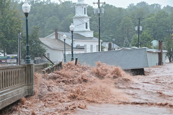
) There are many villages cut off and heavy rescues operations underway. Entire towns are being evacuated. The sheer overgrown nature of these heavily wooded states makes aerial coverage of just how extensive the floodwaters are quite difficult, and we won't really know until morning.


This was taken earlier today. A few hours later the levels of flood water on this street were over six feet.

Photos of flooding here: http://abclocal.go.com/wabc/gallery?sec ... 71&photo=1

What we do know is that people are being rescued from rooftops in the Catskills, that many communities in Southern Vermont are heavily flooded including Brattleboro, Wilmington and Bennington. Bridges are washed away in many places. In some places the waters are still rising but in many communities the levels are now thankfully receding. National Guard have been deployed. It's hard to gauge how damaging these conditions are, as Vermont, new England, New York State and Pennsylvania don't have much experience with natural disasters, so they don't have any basis for comparison in their reporting. Plus Chinese whispers on Twitter may be causing an appearance of a greater calamity than is. But we are definitely looking at a lot of infrastructure damage, massive low level flooding damaging a lot of homes and areas of extreme flooding endangering lives, with some lives lost already.

Expect a lot of reporters feeling guilty who are currently mugging to camera out there on the Jersey Shore and abruptly dropping everything and flying inland.

_________________
"Peter you've lost the NEWS!"

Bored? Why not look at some pretty pictures on my photography blog? Here: http://petetakespictures.com

Come & See My Flickery Pics Here: http://www.flickr.com/photos/nervouspete/


Top
 Profile  
 
Display posts from previous:  Sort by  
Reply to topic  [ 23 posts ] 

All times are UTC [ DST ]


Who is online

Users browsing this forum: Majestic-12 [Bot] and 0 guests


You cannot post new topics in this forum
You cannot reply to topics in this forum
You cannot edit your posts in this forum
You cannot delete your posts in this forum
You cannot post attachments in this forum

Search within this thread:
You are using the 'Ted' forum. Bill doesn't really exist any more. Bogus!
Want to help out with the hosting / advertising costs? That's very nice of you.
Are you on a mobile phone? Try http://beex.co.uk/m/
RIP, Owen. RIP, MrC. RIP, Dimmers.

Powered by a very Grim... version of phpBB © 2000, 2002, 2005, 2007 phpBB Group.